Airport realigns taxiway after stabilizing and reclaiming large pond
When Henry County Airport in Paris, Tenn. realigned its aging parallel taxiway, a body of water stood in the way.
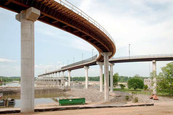
The taxiway project upgraded the runway centerline-to-taxiway centerline separation to meet Federal Aviation Administration standards and now provides pilots with a new, smooth surface. The taxiway had originally been constructed with a 225-foot offset, which helped the taxiway avoid an adjacent pond. However, when the airport later extended Runway 2/20 and its taxiway to 5,000 feet, the distance between the new pavements' centerlines was increased to 300 feet. This created a dogleg in the parallel taxiway.
"When we added more than a thousand feet to the runway and taxiway 20 years ago, we also put in an instrument approach," explained Airport Manager Don Davenport. "With that instrument approach, we had to have a 300-foot separation. Instead of going to the expense of moving the original taxiway, the FAA let us operate under a waiver until we got the useful life out of the pavement."
Davenport said the taxiway had finally aged to the point that it wasn't cost effective to continue maintenance, and it was time to relocate the taxiway by 75 feet and achieve the standard separation. But moving 3,400 feet of asphalt pavement farther away from the runway would also run the taxiway across a 3-acre pond.
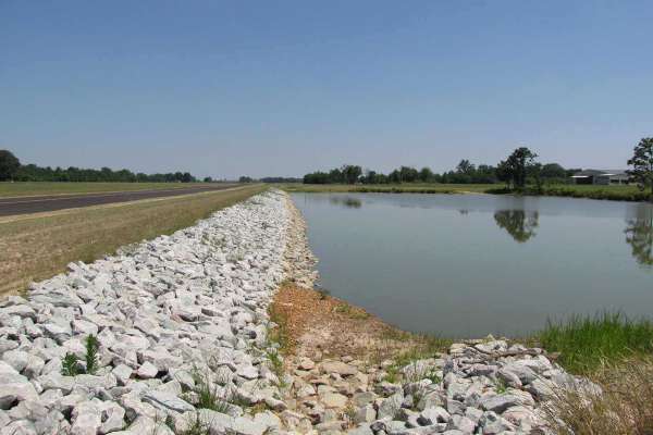
Garver worked with Henry County Airport and developed a design solution. To relocate the taxiway, the pond needed to be drained, stabilized and reclaimed. This involved placing an 18-inch-thick layer of rock on the pond's bottom and constructing a 40-foot-wide, 500-foot-long embankment along the pond's western edge to support the relocated taxiway's heavy load. The low-lying pond was reclaimed due to its vital involvement in airfield drainage patterns—both receiving runoff and discharging stormwater.
Over the Pond and Under Budget
Designing the airfield improvement required an accurate cross section of the pond's bottom and measurements of the muck depth. Garver surveyors used a flat-bottom boat and a GPS robotic total station to survey a grid along the pond bottom and gather the needed data.
"Because this work was performed during winter conditions, the rodman and crew had to break up accumulating ice to complete the survey and muck measurements," said Garver Project Manager Ryan Sisemore, PE. "While the work was physically taxing, we needed the measurements to determine excavation quantities and rock fill stabilization, and we determined that the muck ranged between 3 and 6 feet deep."
To stabilize the pond bottom for embankment construction, the contractor removed 5,000 cubic yards of pond sediment down to firm earth. A full-width geotextile fabric was positioned as a separation layer before placing an 18-inch-thick layer of rock. On-site borrow fill was then compacted in lifts to create the embankment.
To protect the new embankment from saturation once the pond refilled, a layer of clay was used as a cap. Finally, a layer of geotextile fabric and riprap was placed over the clay to protect it against erosion.
Rather than hauling in quarried limestone for bank stabilization, Garver worked with the contractor to use 2,400 tons of locally accessible bank-run gravel. "With transport expenses growing higher due to fuel costs, identifying locally available materials played a key role in cost control and producing an environmentally conscious project," Sisemore said.
This material change dropped the price per ton from $29 to $16 and netted a $31,200 savings.
"Using material on site kept us under budget, and finishing under budget is very important to me," Davenport said. "We are a local county government, and funding can be an issue. The county went out on a limb for us because the project spanned two fiscal years. We were able to handle the project without going into debt, and Garver, the state and federal funds were helpful in that."
Protecting Downstream Water Resources
Garver also worked with the Tennessee Department of Environment and Conservation to develop a Stormwater Pollution Prevention Plan that protected downstream water resources from sediment during the construction process.
"Because the project was both large and complicated, the plan went well beyond a typical level to provide the necessary protection," Sisemore said.
Protective measures included constructing a dewatering structure for the pond reclamation to slow the water release and ensure that adequate time was provided for any sediment drop. The project also integrated additional environmental components, such as delineating an adjacent wetland and extensive mitigation efforts.
Stream Mitigation
Garver worked with the Tennessee Department of Environment and Conservation to also mitigate a stream that needed to be encapsulated in culvert for the relocated taxiway. The mitigation method restored existing stream on a 1.5 to 1.0 ration. Modifications to an on-site stream were designed to incorporate the new length and create riparian zones around the new stream paths as well as restore the channel pattern, profile, and dimensions.
Riparian zones are wooded areas along the stream banks that are essential for aquatic species because they provide a stream with greater ability to maintain consistent temperatures. These zones also protect the stream from sediment, which may be carried from adjacent farm-land areas.
In addition, Garver also investigated and chose plants that do not attract birds or wildlife, which can be hazardous to aircraft.


Share this article