Better tools, better outcomes
Seeing is believing: The next evolution in project delivery

The way infrastructure projects are designed, communicated, and built has continually evolved over the years. We moved from hand-drawn plans to computer-aided design. We transitioned from stacks of paper drawings to digital files accessible from nearly anywhere. Every advancement has improved how information moves from owners to designers to the people responsible for bringing projects to life.
For decades, construction and field teams have relied on two-dimensional drawings to understand three-dimensional solutions. Experienced engineers, inspectors, contractors, and field personnel become highly skilled at reading plans and visualizing what the finished product will look like. But at the end of the day, that's still what it is: visualization.
We're taking information on a sheet of paper and using our experience and imagination to picture how it will fit into the real world.
There are several tools that have entered the construction space that have increased the pace and efficiency of delivering construction projects; and as stewards of the client and the public’s time and dollars, we love nothing more than to find the most cutting-edge ways to do this.
Decades ago, the job of designers became more efficient with the advent of CAD software. Today, surveyors are able to make more precise and immediate calculations thanks to the advent of LiDAR technology. And for us on-site construction engineers and inspectors, there’s no shortage of new tools that we can integrate into our processes, most notably drone mapping and augmented reality software options.
Eyes in the skies
As on-site CE&I providers, it is our aim to deliver projects that meet both the expectation for what was designed and the standards of the public. And utilizing the latest technology is integral in our teams doing so.
For example, drone mapping software, such as Propeller, allows us to capture and access survey-grade data covering the entirety of a construction project, beneficial in helping to make sure a project is on time, on schedule, accurate, and safe for those on the job site. Currently using this software on large highway and bridge projects for major DOT clients, we’ve found it to be an efficient and safe method for evaluating issues related to drainage, quantities, progress tracking, and claims.
A member of the CE&I team can gather data with a drone and then, while utilizing the drone mapping software, simulate where water runoff is likely to pond based on the design. This can help identify any potential drainage issues early enough in the process to be corrected if needed.
Or, with regard to material quantities, this software allows teams to confirm what is being constructed matches slope ratio according to the design, or seeding around the project limits. It’s also a great tool for tracking regular progress of the project, considering regular flights to acquire this data provides an up-to-date picture of what is on the project site.
And because the data is analyzed off site, it not only increases efficiency, but decreases time for personnel on the project site, making it safer for the project team.
Beyond the drawing sheet
Rather than asking project teams to interpret design intent from drawings, AR software, such as Trimble SiteVision, allows us to place the design directly into the field environment where the work will occur. Using design models paired with precise positioning technology, teams can see proposed infrastructure at its actual location and scale before construction begins.
The significance of that shift goes far beyond creating impressive visuals. It helps eliminate one of the biggest challenges in project delivery: the gap between design intent and field understanding.
Many projects don’t start with a blank slate. Much of the infrastructure we work on involves expanding, rehabilitating, or modernizing facilities and systems that are already in operation. Whether it's a water treatment plant, a transportation corridor, or an industrial facility, we're often trying to fit new equipment, utilities, and structures into environments that are already full of existing infrastructure.
That complexity can make project execution difficult. A design may look perfect on a plan sheet but encounter unforeseen conflicts once construction begins. Traditionally, discovering those issues often happened in the field, where resolving them can lead to schedule impacts, change orders, and additional costs.
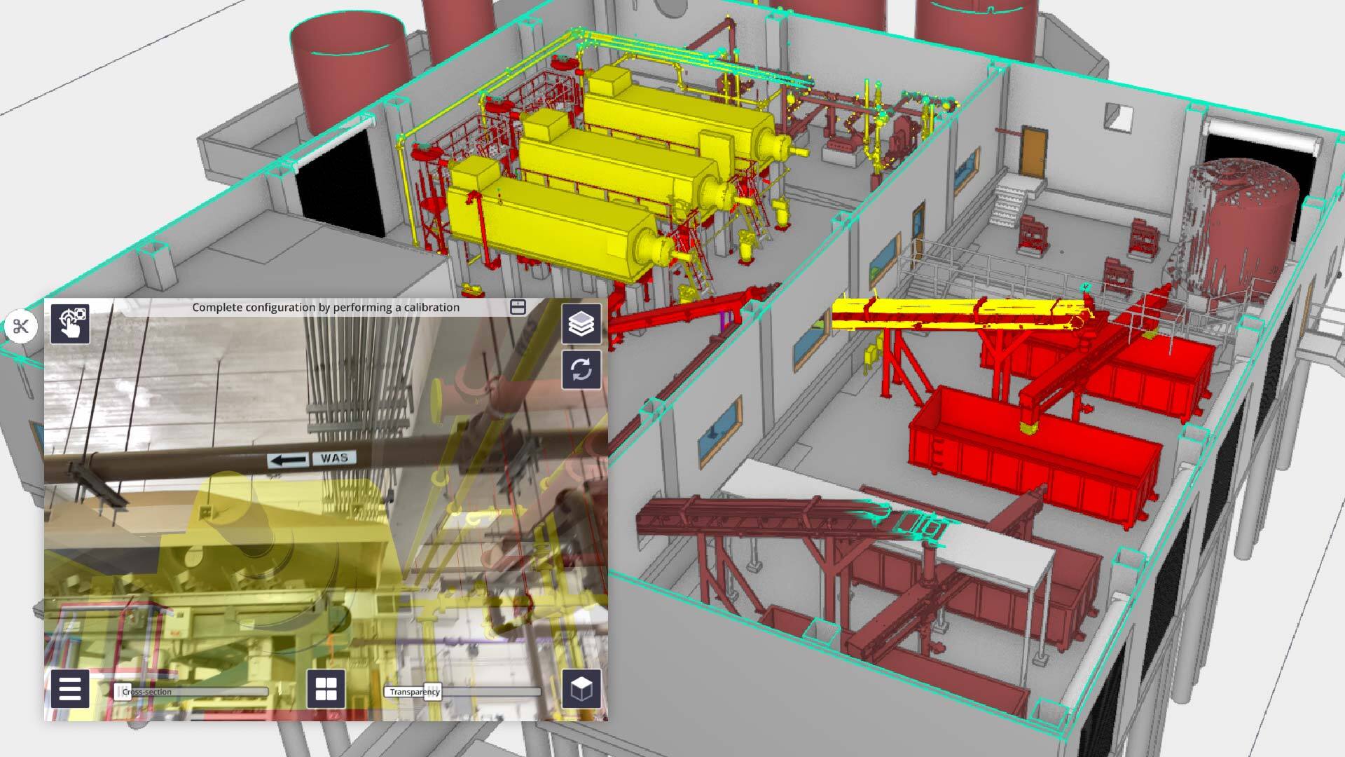
By using AR technology, we have the opportunity to identify many of those challenges earlier, leading to more efficient solutions.
In one recent project that required replacing 30-foot long, 20,000-pound screw presses at a wastewater treatment plant, that capability helped us identify potential conflicts involving ductwork and electrical conduits long before construction activities reached those areas. In this instance, AR technology helped us identify the location of electrical conduits running directly above the screw press. Meaning, if that screw press needed to be removed, it would be blocked by the conduit, which powers the processing equipment for the plant. This catch allowed us to move the conduits, and because the issues were discovered early, the project team was able to coordinate solutions before installation occurred, avoiding schedule impacts and unnecessary rework.
That's where the true value of this technology becomes apparent. It's not about producing a better picture. It's about making better decisions earlier.
The power of early insight
The communication benefits are equally impressive. AR and drone mapping technology create a common visual language that connects engineers, contractors, owners, operators, and stakeholders. When everyone is looking at the same virtual infrastructure in the same physical location, conversations become more productive and informed.
The result is improved coordination, reduced risk, and greater confidence in project execution. At Garver, we embrace technology when it creates meaningful value for our clients and project teams. We're not interested in innovation for innovation's sake. We're interested in solutions that help improve communication, increase efficiency, reduce risk, and save money.



Share this article